Low-Cost GPS-Based Navigation and Tracking System
Design and Implementation of a GPS-Based Navigation and Fleet Tracking Platform for Intelligent Transportation, Autonomous Vehicles, and Drones.
Developed a cost-effective GPS-based navigation and vehicle-tracking platform that combines real-time tracking, offline trip recording, interactive geospatial visualization, online fleet monitoring and comprehensive trip analysis.
Vehicles record their positions during daily operations; trips are then replayed and analyzed on a local server without continuous internet connectivity, or remotely through an online version in a web browser. Speed, distance, stops, driver behavior and estimated fuel consumption come together in one fleet-management workflow.
- Hardware
- GPS receiver + Raspberry Pi 4 Model B with local storage
- Operating modes
- Offline recording, local or online server, real-time tracking
- Analysis
- Playback, speed violations, stops, distance, duration, fuel estimate
- Field use
- Five-unit fleet trial, followed by a request for 30 units
How it is built
System Architecture and Hardware
The system uses a GPS receiver, a Raspberry Pi 4 Model B single-board computer and local storage to record vehicle movements. During a trip the GPS receiver supplies geographic coordinates and time information, and the system records the data locally for later processing.
Data path from the vehicle to the analyst
Implemented system-
GPS Receiver
Geographic coordinates and time
-
Raspberry Pi 4 Model B
On-vehicle computer that records the trip
-
Local GPS Data Storage
Positions and timestamps kept on the device
-
Data Transfer
When the vehicle returns, or as required
-
Offline or Online Server
Local serverOnline server -
Map Visualization & Trip Analysis
Playback, reports, speed, stops, distance, fuel
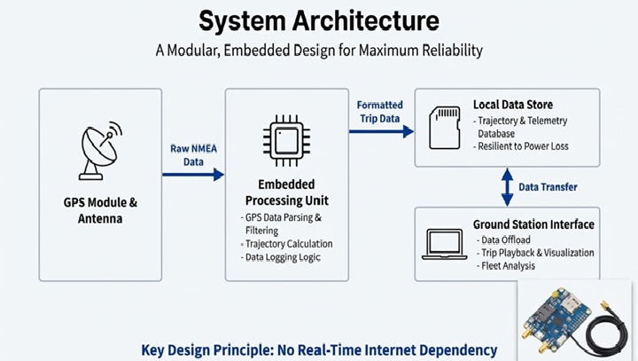
Recording now, analyzing later
Recorded trips can later be transferred to a company server for playback, reporting and analysis. Depending on operational requirements, the platform uses a local offline server, an online server, or both.
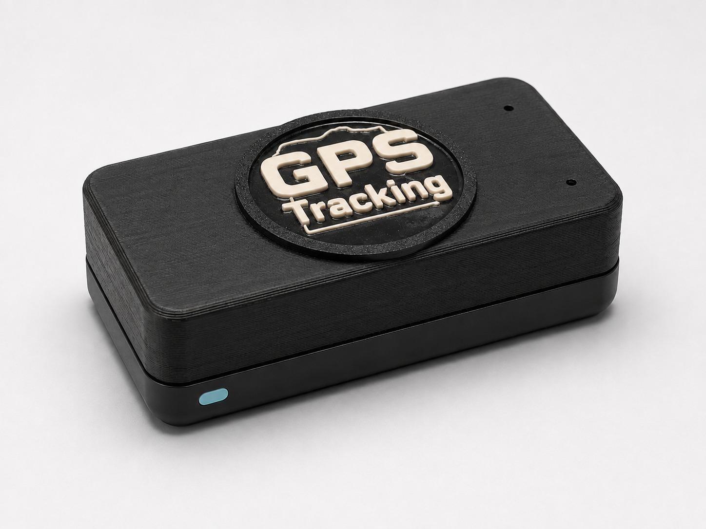
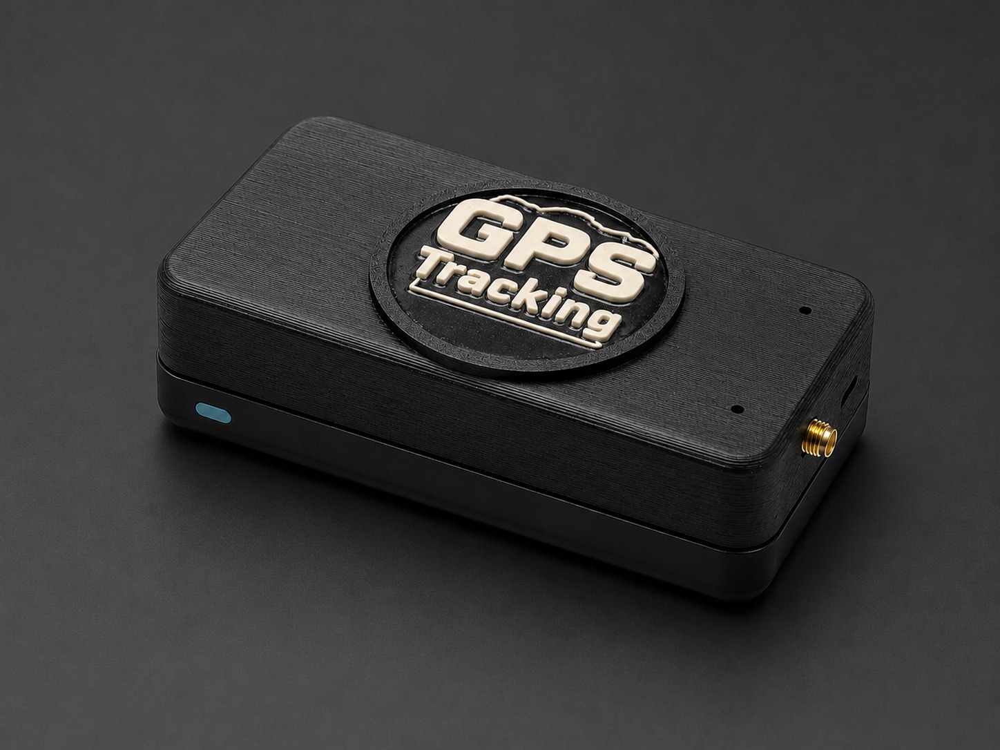
GPS Tracking Version 01
GPS Tracking Version 01 — Offline Fleet Tracking and Analysis System
The offline system works like a vehicle black box. Instead of continuously transmitting GPS data over mobile networks, it records the journey locally. When the vehicle returns to the company, the recorded data is transferred to a local server or an online server, according to the customer's requirements.
When local recording is the better choice
- Mobile-network coverage is poor or unavailable.
- The company wants to reduce recurring SIM and cloud-service costs.
- Vehicles travel across borders or through remote areas.
- The organization prefers to keep vehicle-location data within its own infrastructure.
- Historical trips must be reviewed after a vehicle returns.
- Driver behavior and speed violations need to be investigated.
.jpg)
Offline workflow
- On the vehicle
Collect
GPS coordinates and timestamps are collected during vehicle operation.
- On the vehicle
Store locally
The recorded data is kept on the unit, with no live connection required.
- At the company
Transfer
The data is transferred to the company's local or online server.
- At the company
Select vehicle & trip
The analyst chooses the company, vehicle, date and time window to review.
- Analysis
Replay the journey
The recorded trip is replayed on an interactive digital map.
- Analysis
Analyze the trip
Speed, distance, stops, route history and other trip indicators are reviewed.
- Reporting
Report
A comprehensive trip report is generated and can be printed or saved as PDF.
Inside the software
Interactive Trip Playback and Vehicle Analysis
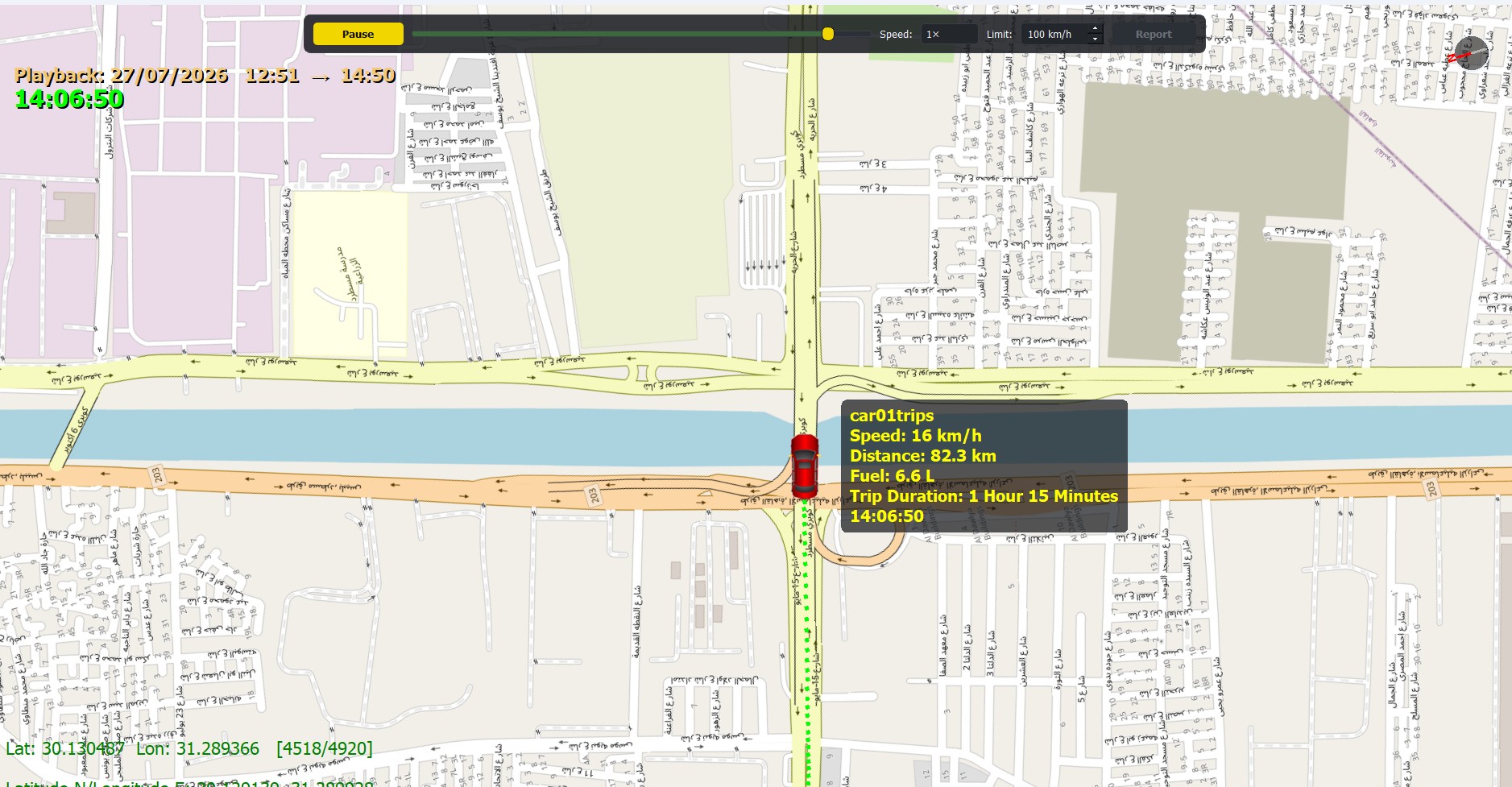
The playback application turns a stored trip back into motion on a digital map, so an analyst can see where the vehicle went, how fast it travelled, where it stopped and whether it exceeded the configured limit.
- Interactive digital-map visualization
- Smooth map zooming and navigation
- Vehicle trajectory visualization
- Playback of historical trips
- Adjustable playback speed
- Vehicle speed and position over time
- Configurable speed limit for the trip review
- Detection of speed-limit violations
- Identification of stops and stopping duration
- Total trip distance and duration
- Review of route and driver behavior
From trip selection to printed report
Screenshots of the playback software, in the order an analyst uses it. Select any image to enlarge it.
-
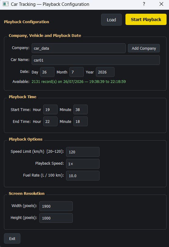
STEP 01 Configure the playback Choose the company, vehicle, date and time window; the tool reports how many records are available. Speed limit, playback speed and fuel rate are set before starting. -
STEP 02 Replay the trip on the map The vehicle follows its recorded trajectory with running speed, distance, estimated fuel and duration. The control bar scrubs through the trip and changes playback speed and speed limit. -
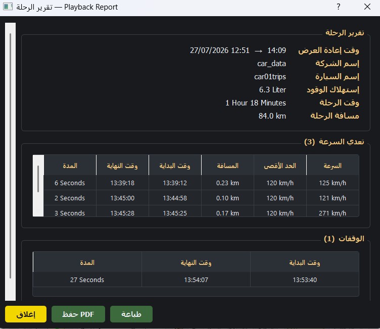
STEP 03 Review the trip report Trip summary (Arabic interface) with distance, duration and estimated fuel, followed by every speed-limit violation and every stop with its duration. -
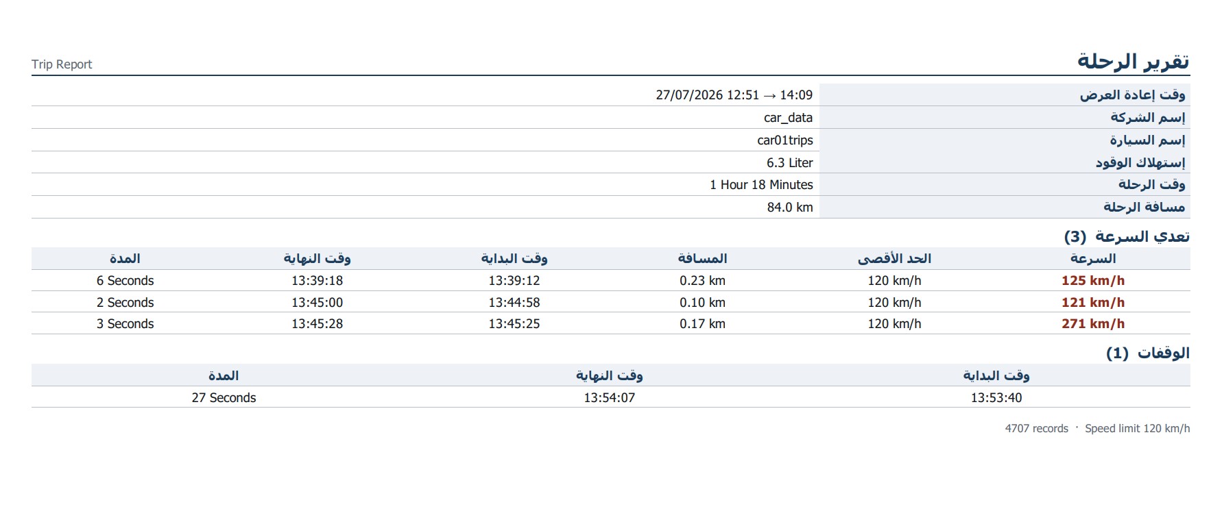
STEP 04 Print or save as PDF The same report laid out for printing or saving as a PDF document.
What the analysis looks for
Explanatory illustrations; the values shown in them are examples, not measured results.
-
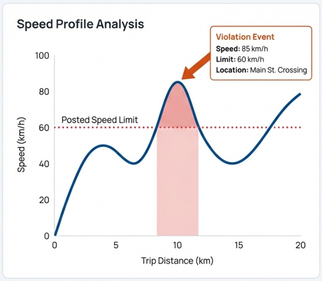
Illustration Speed profile against a posted limit: the segment above the line is reported as a violation. -
.jpg)
Illustration Speed violations and position-over-time playback support driver-behavior review.
Web platform
Online GPS-Based Vehicle Tracking and Fleet Analysis
I developed an online GPS-based vehicle tracking and fleet-analysis platform designed for companies operating multiple vehicles that need reliable monitoring, historical analysis, and actionable operational insights.
The system processes GPS latitude, longitude, and time information to reconstruct vehicle trajectories and calculate movement-related indicators.
Through a web-based interface, authorized users can access the platform from desktop computers, tablets, and mobile phones. The system supports remote vehicle monitoring, route visualization, trip-history analysis, and reporting.
The platform is designed to complement the offline version, giving organizations the flexibility to choose online monitoring, local-server processing, or a combination of both.
Key analysis capabilities
- Vehicle location and route history
- Vehicle speed and movement analysis
- Speed-limit violation detection
- Stops and stopping duration
- Total trip distance
- Trip duration and timestamps
- Fuel-consumption estimation
- Driver-behavior and driving-performance analysis
- Vehicle utilization and operational performance
- Comprehensive trip and vehicle reports
Fleet-level analysis
Project illustrations of the analysis views; the figures in them are examples. This portfolio page does not connect to live vehicle telemetry.
-
.jpg)
Illustration Per-trip performance: distance, duration, idle time and estimated fuel. -
.jpg)
Illustration Aggregating trips from every vehicle to compare drivers, routes and vehicles.
Field testing
Real-Time GPS Tracking and Validation
A real-time version was implemented and tested on a moving car, using a GPS receiver connected to a Raspberry Pi. During operation the system calculated the vehicle's position, speed and travelled distance.
These results were compared with the car's dashboard speedometer and trip meter to evaluate the tracking calculations. The real-time results were also compared with those obtained from offline trip playback of the same kind of recorded data.
This is practical engineering validation against the instruments a driver already trusts, not a laboratory-grade accuracy certification.
Comparisons performed
- Calculated speedGPS + Raspberry Pi, real time VS SpeedometerVehicle dashboard
- Calculated distanceGPS + Raspberry Pi, real time VS Trip meterVehicle dashboard
- Real-time resultsLive calculation during the drive VS Offline playbackPost-trip calculation
Qualitative summary of the tests; no numerical accuracy figures are claimed.
Why distance matters
Reliable distance calculation is the foundation for route analysis, vehicle-utilization reporting and fuel-consumption estimation. If distance is wrong, every indicator built on it inherits the error.
Fuel figures are estimates. Calculated fuel consumption is derived from distance and a configured fuel rate. Real fuel usage also depends on vehicle condition, engine characteristics, load, route, traffic and driving conditions.
Coordinates to map
Geospatial Processing and Accurate Map Visualization
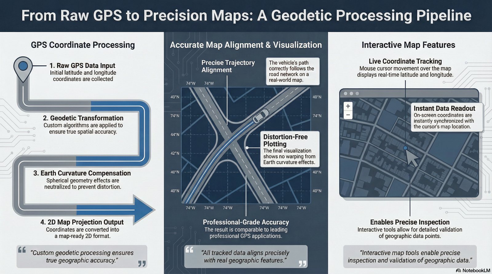
GPS latitude and longitude describe positions on the curved surface of the Earth. Before they can be drawn on a two-dimensional map, they need appropriate coordinate processing.
The project uses custom geodetic transformation algorithms to convert geographic coordinates into map-compatible coordinates, accounting for the relevant geometric and projection effects.
The goal is that recorded trajectories are plotted consistently against the digital map, and that the displayed routes correspond as closely as practical to the underlying geographic positions. In the playback screenshot above, the route follows the road network and the latitude/longitude under the cursor is shown in the corner of the map.
Case study
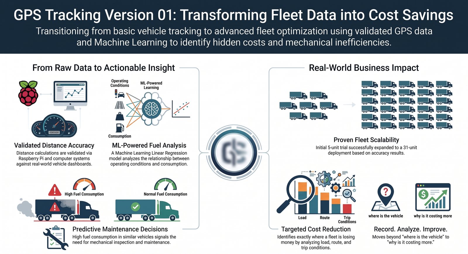
From GPS Tracking to Fleet Cost Analysis
A fuel-consumption question from a fleet owner, answered with validated distance data and a linear-regression model.
- GPS Data
- Distance Calculation
- Trip Analysis
- Fuel-Consumption Analysis
- Linear Regression
- Maintenance Investigation
- Fleet-Cost Optimization
- Trial
Five units, five cars
A company owner deployed five GPS tracking units across five cars as a trial.
- The question
How accurate is the fuel figure?
After three days, the owner asked about the accuracy of the fuel-consumption calculations.
- Foundation
Distance already validated
The system's distance calculations had been evaluated on real trips against vehicle dashboard measurements.
- Observation
Two similar vehicles differ
The owner compared two similar vehicles under comparable conditions and observed a significant difference in fuel consumption.
- Analysis
Linear regression
Historical trip data and a machine-learning linear-regression model were used to study how operating conditions relate to fuel consumption.
- Indication
Inspection warranted
The analysis indicated substantially higher consumption for one vehicle, suggesting mechanical inspection and maintenance attention.
- Outcome
30 units requested
Impressed with the distance and fuel-analysis results, the owner requested 30 GPS Tracking Version 01 units for the fleet.
What the model does and does not show. The regression model supports analysis and decision-making: it flagged a vehicle whose consumption did not fit the pattern of comparable vehicles. It does not, by itself, establish the mechanical cause; that requires inspection of the vehicle. No fuel-saving percentage or model-accuracy figure is claimed here.
Planned development
Future Enhancement — GPS and IMU Data Fusion
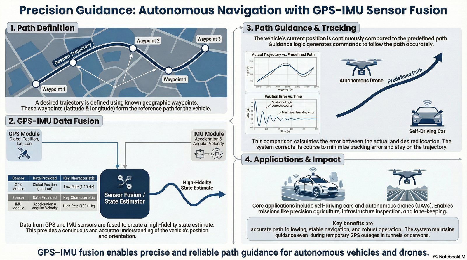
Integrating the GPS receiver with an Inertial Measurement Unit (IMU) could improve navigation continuity when GPS signals are temporarily unavailable or unreliable, for example in tunnels or dense urban environments.
The planned system would combine GPS measurements with inertial data to estimate vehicle motion and keep a position estimate during short periods of GPS interruption.
Inertial navigation errors accumulate over time. How good the estimate remains depends on the sensors, their calibration, the fusion algorithm and how long GPS is unavailable, which is why the approach targets short interruptions rather than replacing GPS.
.jpg)
Planned development
Future Enhancement — Path Guidance for Autonomous Vehicles and Drones
A proposed extension that reuses the platform's positioning and map processing to give a navigation or control system guidance information along a predefined route.
Proposed approach Planned
- Define routes using geographic waypoints.
- Compare the estimated vehicle position with the predefined path.
- Use GPS and, where appropriate, IMU measurements to estimate motion.
- Calculate path-following deviations.
- Provide guidance information to a navigation or control system.
Potential applications include autonomous ground vehicles, intelligent transportation and unmanned aerial vehicles (UAVs), where a vehicle must follow a known path and report how far it is from it.
.jpg)
Implemented today vs. proposed next
See it working
Project Demonstrations
Recorded walkthroughs of the GPS tracking system.
-
Video 1
GPS Tracking System Demonstration
Video demonstration will be available soon.
Video 1 — GPS Tracking System Demonstration
Project 3.mp4 -
Video 2
GPS Tracking System Demonstration (Arabic)
Video demonstration will be available soon.
Video 2 — GPS Tracking System Demonstration (Arabic)
Project 3_ar.mp4 -
Video 3
Additional Project Demonstration
Video demonstration will be available soon.
Video 3 — Additional Project Demonstration
last.mp4
Skills applied
Engineering Capabilities Demonstrated
-
GPS Navigation and Tracking
- GPS data acquisition
- Position, speed and distance calculations
- Real-time tracking
- Historical trip reconstruction
-
Embedded Systems
- Raspberry Pi 4 Model B
- GPS receiver integration
- Local data recording and storage
-
Geospatial Systems
- Geographic-coordinate processing
- Geodetic transformations
- Digital-map visualization
- Vehicle trajectory rendering
-
Data Analysis
- Trip playback and reporting
- Speed-limit violation analysis
- Stop detection
- Fuel-consumption estimation
- Linear regression for fleet analysis
-
Software and System Integration
- Offline and online architectures
- Database-backed tracking applications
- Web-based fleet monitoring
- Data-driven operational reporting
Where it fits
Practical Applications
Any organization that runs vehicles and needs to know where they went, how they were driven and what they cost can use the platform. The autonomous and UAV entries are research directions tied to the planned enhancements above.
- Fleet management
- Logistics and transportation
- Oil and gas operations
- Construction
- Agriculture
- Industrial operations
- Vehicle rental
- Bus and transportation services
- Intelligent transportation
- Autonomous vehicles (research)
- UAV and drone navigation (research)
Contact & Collaboration
Running a Fleet or Building Navigation Systems?
I welcome discussions about GPS tracking, fleet analytics, geospatial processing and navigation research for intelligent transportation, autonomous vehicles and drones.